Chapter
8--
Air Masses
TEST 3 APRIL 13TH, Chapter 6, 7 and 8.
In the middle latitudes, most weather patterns are the result of the movements of large bodies of air, called air masses. An air mass is a large body of air, usually 1600 kilometers or more across and perhaps several kilometers thick, which is characterized by homogeneous physical properties (in particular, temperature and moisture content) at any given altitude. A region under the influence of an air mass will probably experience generally constant weather conditions, a situation referred to as air-mass weather.
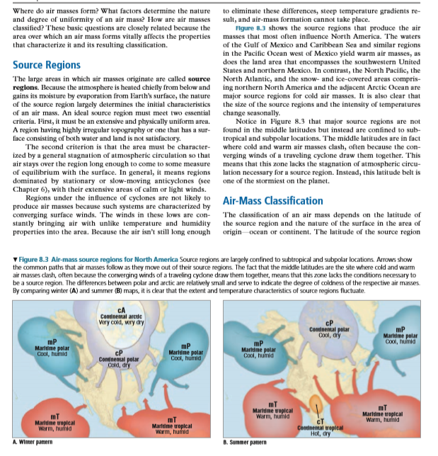
Areas in which air masses originate are called source regions. An ideal source region must meet two criteria. First, it must be an extensive and physically uniform area. The second criterion is that the area is characterized by a general stagnation of atmospheric circulation so that air will stay over the region long enough to come to some measure of equilibrium with the surface.
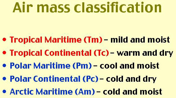
The classification of an air mass depends on (1) the latitude
of the source region, and (2) the nature of the surface in the area of origin—ocean
or continent. Air masses are identified by two-letter codes. With reference
to latitude (temperature), air masses are placed into one of three categories:
polar (P), arctic (A), and tropical (T). A lowercase letter (m, for maritime,
or c for continental) is placed in front of the uppercase letter to designate
the nature of the surfaces in the source region and therefore the humidity
characteristics of the air mass. Using this classification scheme, the following
air masses are identified: cA, cP, cT, mT, and mP.
Air Mass Classification
Based on source region temperature and moisture properties.
BELOW VIDEO CHAPTER 7 AND CHAPTER 8.
Chapter 8 Video (131 views- 11-1-22)
IMPORTANT PAGES TO LOOK AT
pages 206-212. Air masses on Page 207
Table 8.1 Page 208
 |
 |
 |
 |
 |
 |
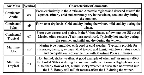
c - continental (land)
m - maritime (water)
P - polar (cold)
A - arctic (extremely cold)
T - tropic (warm)
cP - cold, dry, stable
cT - hot, dry, stable air aloft, unstable at surface
mP - cool, moist, unstable
mT - warm, moist, unstable
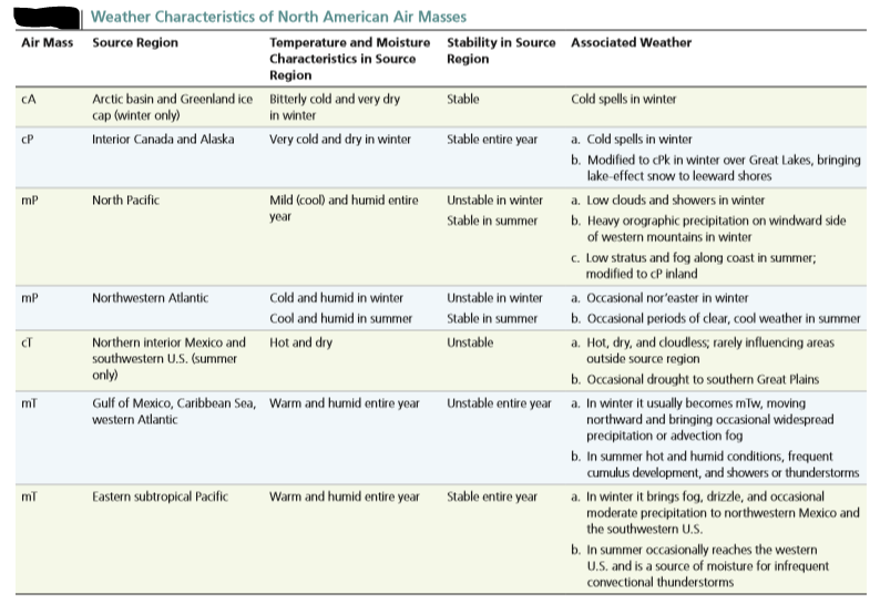
Once an air mass moves from its source region, it not only modifies the weather of the area it is traversing, but it is also gradually modified by the surface over which it is moving. Modifications can result from temperature differences between an air mass and the surface, vertical movements induced by cyclones and anticyclones, or topography.
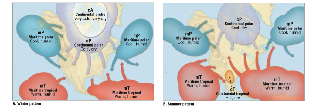
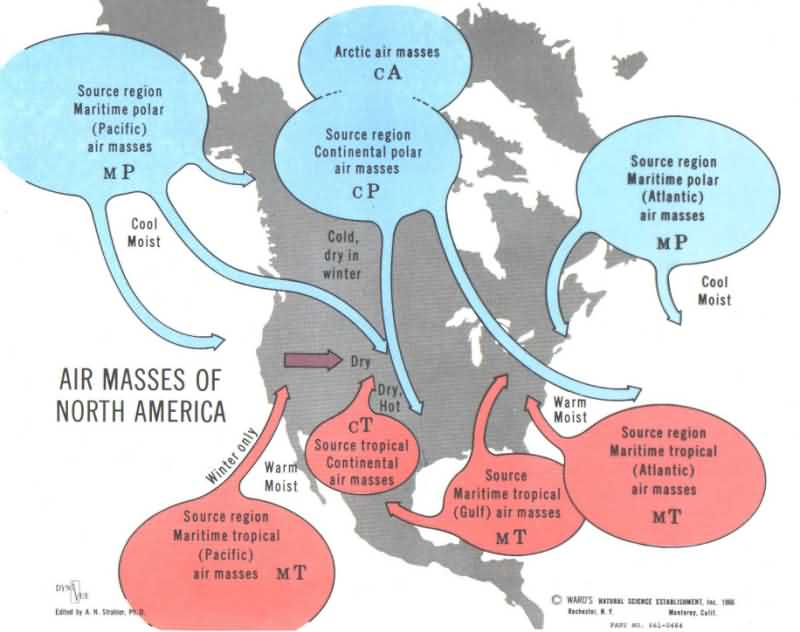
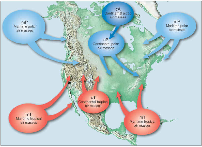
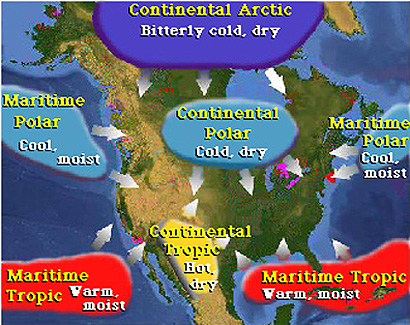
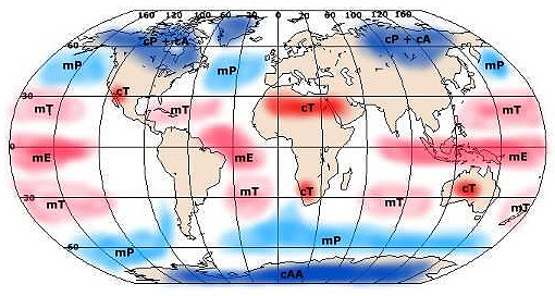
The day-to-day weather we experience depends on the temperature, stability, and moisture content of the air mass we are experiencing. Continental polar (cP) and continental arctic (cA) air masses are, as their classification implies, cold and dry. Although cP air masses are not, as a rule, associated with heavy precipitation, those that cross the Great Lakes during late autumn and winter sometimes bring lake-effect snows to the leeward shores. Maritime polar air masses (mP) form over oceans at high latitudes and are cool to cold and humid. The weather associated with an invasion of mP air from the Atlantic into an area east of the Appalachians and north of Cape Hatteras is known as a nor'easter. Maritime tropical (mT) air masses affecting North America most often originate over the warm waters of the Gulf of Mexico, the Caribbean Sea, or the adjacent western Atlantic Ocean. As expected, mT air masses are warm to hot and they are humid. During winter, when cP air dominates the central and eastern United States, mT air only occasionally enters this part of the country. However, during the summer, mT air masses from the Gulf, Caribbean, and adjacent Atlantic cover a much wider area of the continent and are present for a greater period. The mT air masses from the Gulf-Caribbean-Atlantic source region are also the source of much, if not most, of the precipitation received in the eastern two-thirds of the United States. Isohyets, lines drawn on a map that connect places having equal rainfall, illustrate the greatest rainfall in the Gulf region and a decrease in precipitation with increasing distance from the mT source region. Hot and dry continental tropical (cT) air is produced only in the summer in northern interior Mexico and adjacent parts of the arid southwestern United States.
FOR THE TEST - TEST 3 APRIL 13TH, Chapter 6, 7 and 8. .
Where is the air mass coming from? Is the air mass over land or water? In reference to Long Island, is the air mass coming from the North, then it would be a colder air mass. If the Air Mass is coming from the South, it will be a warmer air Mass. If the Air Mass is coming from a Cold Water or a Warm Water region?
Warm , Humid air mass can bring Thunderstorms.
c - continental (land)
m - maritime (water)
P - polar (cold)
A - arctic (extremely cold)
T - tropic (warm)
cP - cold, dry, stable - full name - continental Polar
cT - hot, dry, stable air aloft, unstable at surface - continental Tropical
mP - cool, moist, unstable - maritime Polar ( Air mass that would produce Nor'Easters )
mT - warm, moist, unstable - Maritime Tropical