


Chapters 3, 4 and 5
Start Here
The videos below are the most important videos to watch as you prepare for Test 2.
Review your class notes, textbook pages, figures, formulas and examples.
Temperature
Remember the formulas. You will NOT have a calculator on the test.
Celsius to Fahrenheit
Fahrenheit to Celsius
Daily Mean Temperature
Know how to calculate the Daily Mean Temperature.
Heating & Cooling Degree Days
Heating Degree Days
When the daily mean is below 65°F:65 − Daily Mean
Cooling Degree Days
When the daily mean is above 65°F:Daily Mean − 65
Controls of Temperature
Know the major controls of temperature:
- Differential heating of land and water
- Ocean currents
- Altitude
- Geographic position
- Cloud cover
- Albedo
Ocean Currents
Understand how ocean currents can influence temperature.
Temperature Scales
- Fahrenheit
- Celsius
- Kelvin
Stability & Moisture
Environmental Lapse Rate
The Environmental Lapse Rate tells us the temperature of the atmosphere and the rate of cooling or warming with height.
It must be regularly measured using radiosondes.
LCL — Lifting Condensation Level
The Lifting Condensation Level is the level where the atmosphere becomes saturated.
Relative Humidity vs. Dew Point
Relative Humidity
Relative humidity is a measure of how near the air is to being saturated.Dew Point
Dew-point temperature is the temperature to which a parcel of air must be cooled to reach saturation.Dew point is a measure of the air's actual moisture content.
Relative Humidity = how close the air is to saturation.
Dew Point = actual moisture content of the air.
States of Water
Know the states of water.
Know what the changes from one state of water to another are called.
Know how many calories are involved in the phase changes discussed in class.
Four Mechanisms That Cause Air to Rise
1. Orographic Lifting
Air is forced to rise over a mountainous barrier.2. Frontal Wedging
Warmer, less dense air is forced over cooler, denser air along a front.3. Convergence
A pileup of horizontal airflow results in upward flow.4. Localized Convective Lifting
Unequal surface heating causes localized pockets of air to rise because of their buoyancy.Atmospheric Stability
UNSTABLE
UNSTABLE
IMPORTANT EXAMPLES
Dry = 10°C
Wet = 6°C
ABSOLUTE STABILITY
Dry = 10°C
Wet = 6°C
ABSOLUTE INSTABILITY
UNSTABLE
Dry = 10°C
Wet = 6°C
CONDITIONAL INSTABILITY
UNSTABLE
Environmental Lapse Rate LESS THAN Wet Lapse Rate
= STABLE
Environmental Lapse Rate GREATER THAN Dry Lapse Rate
= UNSTABLE
Air Parcel vs. Environment
Air Parcel is WARMER
If the air parcel is warmer than the environment:UNSTABLE
Air Parcel is COLDER
If the air parcel is colder than the environment:STABLE
Pay special attention to:
Figures 4.24, 4.25 and 4.26
Figures are on Pages 102-103.
Important Chapter 4 Videos
Clouds & Precipitation
Chapter 5 — Part 1
Chapter 5 — Part 2
Rain Cloud — Dark Gray
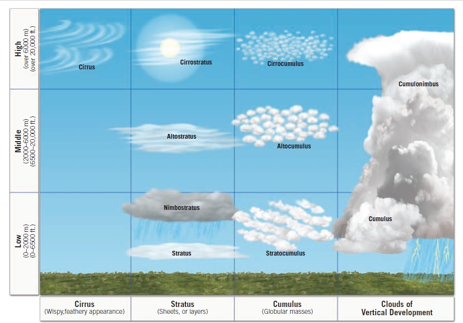
Clouds of Vertical Development
Cumulus and Cumulonimbus are clouds of vertical development.
They develop vertically into towers or domes.
Clouds Based on Form & Height
Review Table 5.1.
CLOUDS ARE CLASSIFIED BASED ON FORM AND HEIGHT.
Three Basic Cloud Forms
High, white and thin.
Globular, individual cloud masses.
Sheets or layers.
Cloud Heights
Bases above 6,000 meters / 20,000 feet
Remember: CIRRUS
Approximately 2,000-6,000 meters
Remember: ALTO
Below approximately 2,000 meters / 6,500 feet
Remember: STRATUS
Based on form and height, ten basic cloud types are recognized, including cirrostratus, altocumulus and stratocumulus.
Precipitation
LOOK AT PAGES 129-132.
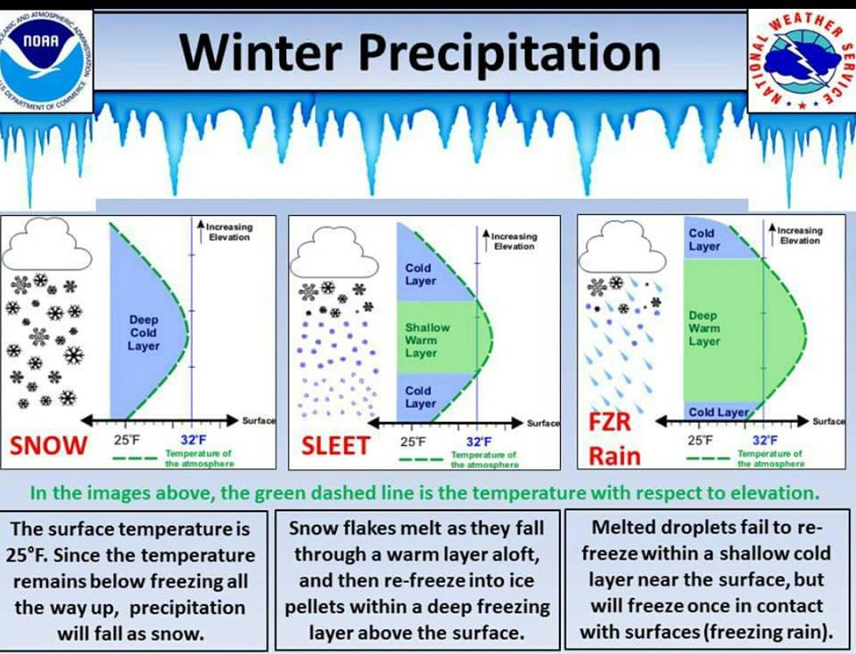
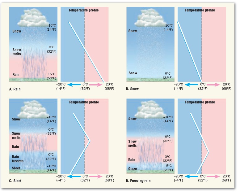
Winter Precipitation
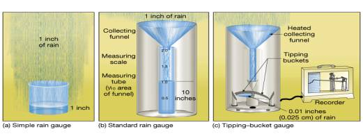
How Do We Measure Precipitation?
Know these precipitation instruments:
- Simple rain gauge
- Standard rain gauge
- Tipping-bucket gauge
Test 2 Final Checklist
Before the exam, make sure you can answer each of these without looking at your notes.
- Temperature conversion formulas
- Calculate Daily Mean Temperature
- Heating Degree Days
- Cooling Degree Days
- Remember 65°F is the magic number
- Ocean Currents
- Controls of Temperature
- Temperature Scales
- Environmental Lapse Rate
- Normal Lapse Rate — 6.5°C/km
- What is the LCL?
- What happens when RH reaches 100%?
- Difference between Relative Humidity and Dew Point
- States of Water
- Names of the changes in the state of water
- Calories involved in phase changes
- Four mechanisms that cause air to rise
- Absolute Stability
- Absolute Instability
- Conditional Instability
- Warmer parcel vs. colder environment
- Colder parcel vs. warmer environment
- Three basic cloud forms
- Cloud classification by height
- Nimbo / Nimbus
- Clouds of Vertical Development
- Cumulus and Cumulonimbus
- Table 5.1 — Pages 117-118
- Precipitation — Pages 129-132
- How precipitation is measured
- Watch the important Chapter 3, 4 and 5 videos
TEST 2 — OCTOBER 14, 2026
CHAPTERS 3, 4 AND 5